| KisMAC Manual - The Map View |
KisMAC's internal map support
In order to use KisMACs mapping support, you will need to get a map first. You can do this by either importing images (eg. scanned maps) or you can tell KisMAC to import maps from an internet server. The advantage of the internet servers is that (at least for Map24 and Expedia) no alignment has to take place. Please be aware that the servers only have maps for specific areas of the world. You can of course also share stored kismap files with friends.
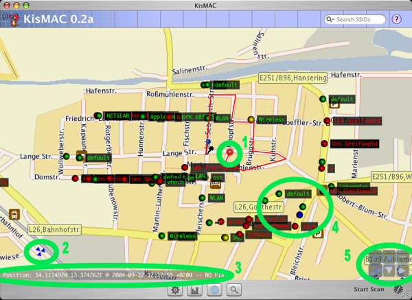
- Your current position is shown in a growing and shrinking circle. You can enable and disable this feature in the map menu. The red line, which follows the circle is your trace. It will be automatically stored in kismac files.
- In order to align maps you will need to set two waypoints, which look like three triangles. Map24 and Expedia maps are automatically aligned and thus have no waypoints.
- In the lower left corner you can see the current status of your GPS device.
- Networks will show up as dots. The SSID (if available) is shown
on the right side. The colors reflect the encryption state of the
network.
- Green - Open node
- Yellow - Unknown node
- Red - WEP node
- Blue - WPA or WPA2 node
- Cyan - LEAP node
- The control panel in the lower right corner allows navigation in the map. You can also use the respective keys on your keyboard (arrow keys/+/-).
| back | Tell me more |